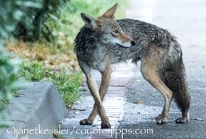
-

-
racing playfully over grasslands
-

-
ravens and squirrels sound the alarm
-

-
hunting in ivy below trees
-

-
heading down an alleyway
-

-
trotting on a street
-

-
arrive at open field and observe
-

-
crossing a street
-

-
observed by two dogs and two men
-

-
heading to wild area in back of house
-

-
descending to wild area in back of houses
-

-
in back of houses
-

-
descending ally stairs
-

-
on a sidewalk
-

-
in the street
-

-
in the street
-

-
a raccoon is in this bush, let’s get it
-

-
waiting for the other coyote
-

-
exploring under houses
-

-
back in the open space watching dog & walker
-

-
hurrying away from people watching
I’ve been mapping some trekking behavior. It occurred to me that documenting coyote behavior during a larger, yet delimited, chunk of time and space would increase our understanding of them: where do they go and what do they do?
What is trekking? It involves the several excursions/tours, both short and long, which coyotes engage in every day. They use these outings to hunt, scout, mark, play, watch, etc. When they are not trekking, they may be just hovering around their home base or sleeping!
Keeping coyotes in sight as they trek along is not easy and can’t be done all the time. For one, I often can’t fit through some of the spaces on their routes. Secondly, most of their trekking is done at night — that’s when I sleep, and anyway, it’s impossible to see and even less possible to record with a camera. So, I limit my observations to times when there is enough daylight. Thirdly, in the wild, another critter would go in their direction only if it was a pursuing predator. I have to be careful how I keep them in sight. If I simply hang around in one location appearing disinterested, they ignore me as a fixture, but this is harder to do as they move along — and may put them on alert, altering the behavior I want to observe.
I have seen how they react to humans and dogs going in their direction, and it makes them uneasy: they look back at them — almost glaring, they poop or mark with urine sometimes while looking at them, they hurry, they are not sure of themselves so they come to a standstill as if they can’t make up their minds how to proceed, they duck out of sight, they watch out of the corners of their eyes. I cut my observations short if I sense any of these signs of discomfort from them.
How much territory do they generally cover? The distance could be as short as 1/3 mile and as long as several miles or longer, as the crow flies. Of course, they do not follow a straight line, they turn back on themselves and wander in all directions, so the amount of territory actually covered is much more than a straight line from point A to point B. They are on the streets and sidewalks, on park paths, they go through thickets and brush, they are on playing fields and golf courses. It’s easy to lose sight of a coyote. I’ve learned to listen for ambient sounds and to use other clues to help me reconnect once I’ve lost sight of them, such as the alarm cries of ravens, squirrels or a red tail hawk, or the sound of a distressed human voice yelling “get outta here!” I’m also aided by patterns of behavior I’ve become familiar with over the years.
Charles has posted excellent observations on rendezvous/reunions engaged in by coyotes before their treks. It’s fairly routine and standard, unless a coyote decides to head off for a little lone activity.
Treks can last half an hour, a couple of hours, or, I’m sure, all night. My observations involve daylight trekking — always delimited by either dusk or dawn when I no longer can see.
The camera time-stamps all my photos, and, of course, the photos show me what is going on and where: it serves as a great notebook, and I don’t need to stop to write anything down! There is immediacy in my first-hand observations and, since I am there, I can pick up on so many things missed by “devices” of any sort. Devices, such as radio collars, cannot give you the full picture. They create one more degree of separation and removal from what you might be able to observe first-hand. They also cause irritations and can cause damage to the animals, including the process of capturing them to put on the collar. I admire the information that can be retrieved from these devices, but, personally, I think they should be used as little as possible.
Here is one of my maps showing time and distance traveled, and context. The photos above go with this map.

Trekking Map #1 [click image to enlarge]


